A Brief Guide to East Jerusalem Neighborhoods
This high-level introductory guide is brought to you by Secret al Quds East Jerusalem, a vibrant community of locals and expats in the area.
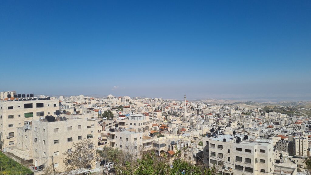
Jerusalem is a complex and diverse city, with a mix of Jewish, Arab, and Christian neighborhoods. The city has been at the center of the Israeli-Palestinian conflict for many decades, and the status of Jerusalem is a highly contentious issue. Palestinian neighborhoods in Jerusalem are primarily located in East Jerusalem, which was occupied by Israel during the 1967 war. These East Jerusalem neighborhoods include:
A-Tur
The name A-Tur comes from the Arabic word “At-Tur,” which means “The Mountain.” This is likely a reference to the Mount of Olives. This neighborhood is located on the Mount of Olives and is home to around 30,000 Palestinians.
A-Tur is a Palestinian neighborhood in East Jerusalem, located on the Mount of Olives, overlooking the Old City of Jerusalem. The neighborhood is home to around 18,000 Palestinian residents, making it one of the largest Palestinian neighborhoods in Jerusalem. A-Tur is primarily a residential area, with a mix of apartment buildings, single-family homes, and small businesses. The neighborhood is known for its stunning views of the Old City and is popular with tourists who come to visit the area’s historic landmarks.
The history of A-Tur dates back to the Ottoman era, when the area was primarily agricultural. After the British Mandate period, the neighborhood grew as more Palestinians moved to Jerusalem from other parts of the country. Following the 1948 Arab-Israeli War, A-Tur became part of Jordanian-controlled East Jerusalem, and many Palestinian refugees settled in the area. In 1967, Israel occupied East Jerusalem, including A-Tur, and subsequently annexed the area, although this annexation is not recognized internationally.
Under Israeli occupation, A-Tur has faced a number of challenges, including restrictions on building permits and home demolitions. Many Palestinian residents of the neighborhood have been displaced as a result of these policies, and tensions between Palestinian residents and Israeli authorities have been high in recent years. The neighborhood has also been impacted by the construction of Israeli settlements in nearby areas, which has led to the displacement of Palestinian families and the fragmentation of the Palestinian community.
Despite these challenges, the residents of A-Tur have maintained a strong sense of community and identity. Local organizations and activists have worked to provide social services and cultural programs in the neighborhood, and there is a strong sense of pride among residents in the history and cultural heritage of the area.
Abu Tor
The name Abu Tor is derived from Arabic, with “Abu” meaning “father” and “Tor” meaning “mountain” or “hill.” The neighborhood is situated on a hillside overlooking the Old City and the Kidron Valley. Abu Tor has a population of around 20,000 people. The neighborhood is situated on a hill, providing excellent views of the city. The neighborhood has a mix of older buildings and new luxury buildings, it also has a mix of traditional and modern culture.
The history of Abu Tor dates back to the Ottoman period, when the area was used primarily for agriculture. During the British Mandate period, the neighborhood began to be developed as a residential area. Following the establishment of the State of Israel in 1948, Abu Tor became part of Israeli-occupied West Jerusalem, and many of its Arab residents were displaced.
In recent years, Abu Tor has become a symbol of coexistence and peaceful cohabitation between Jews and Arabs in Jerusalem. The neighborhood is known for its mixed population, with Jewish and Arab residents living side by side in apartment buildings and single-family homes. Despite occasional tensions and incidents of violence, the residents of Abu Tor are committed to promoting peaceful coexistence and working together to build a better future for their community.
Abu Tor is also known for its religious diversity. The neighborhood is home to several mosques and churches, as well as the Beit Yosef Synagogue, which serves both Jewish and Arab residents. The unique religious and cultural landscape of Abu Tor has helped to foster a sense of tolerance and understanding among its residents.
The neighborhood is also home to several parks and public spaces, including the Haas Promenade, which offers stunning views of the Old City and the surrounding area. Abu Tor is also located in close proximity to several of Jerusalem’s most popular cultural and historical sites, including the Old City, the City of David, and the Mount of Olives.
Al Sawana
Al Sawana is a neighborhood located in East Jerusalem, situated between the Hebrew University Mount Scopus campus and the Old City, and includes the Augusta Victoria hospital. The neighborhood is home to a mix of Palestinian and Jewish residents.
The history of Al Sawana dates back to the Ottoman period, when the area was used as a cemetery. In the early 20th century, the neighborhood began to develop with the construction of homes and institutions, including the Augusta Victoria hospital.
During the 1948 Arab-Israeli War, Al Sawana was occupied by Jordan, and many of the Jewish residents were forced to flee the area. Following the 1967 Six-Day War, the neighborhood was annexed by Israel and became part of East Jerusalem.
Today, Al Sawana is a diverse neighborhood with a mix of residential areas, medical facilities, and educational institutions. The Augusta Victoria hospital is a major medical center that serves both Palestinian and Israeli patients.
The population of Al Sawana is estimated to be around 4,000 residents, the majority of whom are Palestinian Muslims. The neighborhood has faced challenges related to the Israeli-Palestinian conflict, including tensions between Jewish and Palestinian residents, as well as issues related to home demolitions and land confiscation.
Bab a-Zahra
Bab A-Zahra is a neighborhood located in the northeast of Jerusalem’s Old City, near Herod’s Gate.
The name “Bab al-Zahra” means “Gate of the Flower” in Arabic. It is also known as the “Herod’s Gate” in English, as it is believed to be near the site of a gate that existed during the time of King Herod.
In modern times, the neighborhood of Bab A-Zahra has experienced significant growth and development. Many residential buildings, commercial shops, and cultural institutions have been constructed in the area. The neighborhood is home to a diverse population, including both Muslim and Christian Palestinians.
Due to its location near the Old City walls, Bab A-Zahra is a popular tourist destination. Visitors can explore the ancient architecture and learn about the neighborhood’s rich history. The narrow streets and alleys of the neighborhood are filled with markets, cafes, and other businesses, creating a vibrant and bustling atmosphere.
However, like many other Palestinian neighborhoods in Jerusalem, Bab A-Zahra has faced challenges related to the Israeli-Palestinian conflict. There have been ongoing disputes over land ownership and construction permits, which have led to tensions between the residents and the Israeli government.
Despite these challenges, the residents of Bab A-Zahra have continued to preserve their cultural heritage and maintain their community spirit. The neighborhood’s rich history and unique character make it an important part of Jerusalem’s cultural and social fabric.
Beit Hanina
This neighborhood is located in the northern part of East Jerusalem and is home to around 40,000 Palestinians. The name “Beit Hanina” comes from the Arabic words “Beit” meaning “house” and “Hanina” which is derived from the word “hanin” meaning “yearning” or “longing”. It is believed that the name refers to the residents’ longing for the return of their homeland and the end of the occupation. Another theory suggests that the name may have originated from a nun named “Hanina” who lived long ago in the neighborhood and took care of visitors and pilgrims who passed through.
Beit Hanina is a Palestinian neighborhood located in the northeastern part of Jerusalem. The neighborhood has a long and complex history, shaped by political and social forces over several centuries.
The history of Beit Hanina can be traced back to the Canaanite period, when it was a strategic location for trade and agriculture. In the Roman period, the area was known for its olive groves and vineyards, and it became an important center for Christian pilgrimage in the Byzantine era.
During the Ottoman period, Beit Hanina was a center for agriculture and trade, and the neighborhood was home to a mix of Muslim, Christian, and Jewish residents.
After the 1948 Arab-Israeli War, Beit Hanina fell under Jordanian control and was incorporated into the larger Jerusalem municipality. In 1967, Israel occupied East Jerusalem, including Beit Hanina, and annexed the neighborhood along with the rest of the city.
Today, the population is predominantly Muslim, with a significant Christian minority, along with a handful of mixed families and Jewish settlers. The neighborhood has a combination of residential, commercial, and industrial areas, with many Palestinian families – including many originating from Hebron – involved in business and trade.
Like many Palestinian neighborhoods in East Jerusalem, Beit Hanina has faced a range of challenges in recent years. The Israeli government has pursued policies aimed at increasing Jewish settlement in the area, often at the expense of Palestinian residents. There have also been tensions between Palestinian residents and Israeli authorities over issues such as housing and land ownership. Despite these challenges, Beit Hanina remains a vibrant and culturally rich neighborhood, with a strong sense of community and history.
Beit Safafa
The name Beit Safafa comes from the Arabic words “Bayt” which means “house” and “Saffa” which is believed to refer to a local family or tribe. It is a Palestinian neighborhood that is located in the southern part of Jerusalem, it is bordered by the neighborhoods of Gilo, Malha and Bethlehem. It is a relatively small neighborhood with a population of around 12,000 people. Beit Safafa is known for its traditional architecture and it’s well-preserved village center.
Beit Safafa is a predominantly Palestinian neighborhood located in southern Jerusalem, between the neighborhoods of Gilo and Talpiot. The neighborhood is divided into two sections by the 1949 armistice line, with the eastern part falling under Jordanian control until 1967, and the western part coming under Israeli control. The two sections were reunified after the 1967 war.
The history of Beit Safafa dates back to the Canaanite era, with various archaeological discoveries in the area. The village was first mentioned in historical records during the Crusader period, and remained a predominantly Palestinian agricultural community until the establishment of the State of Israel in 1948. During the 1948 Arab-Israeli War, many of the residents of Beit Safafa fled their homes, and the village was divided by the newly established Israeli-Jordanian border.
After the reunification of Jerusalem in 1967, Beit Safafa experienced a significant growth in population, as many Palestinian refugees and their descendants returned to the area. However, the neighborhood has faced a number of challenges, including the construction of the Gilo settlement on its southern edge, which has led to the displacement of Palestinian families and the fragmentation of the Palestinian community. Additionally, the construction of the Israeli separation barrier has further divided the neighborhood, causing disruptions to daily life and hindering economic growth.
Despite these challenges, the residents of Beit Safafa have maintained a strong sense of community and identity. Local organizations and activists have worked to provide social services and cultural programs in the neighborhood, and there is a strong sense of pride among residents in the history and cultural heritage of the area. In recent years, the neighborhood has also become a site for joint Israeli-Palestinian cultural and environmental initiatives, aimed at promoting peace and understanding between the two communities.
Issawiya
This neighborhood is located in the northeastern part of East Jerusalem. The origin of the name Issawiya is disputed. Some sources suggest that it is named after the Issawi family, who were one of the first families to settle in the area. Others suggest that the name is derived from the Arabic word “sawi,” meaning “upper,” which may refer to the fact that the neighborhood is located on the east side of Mount Scopus.
Issawiya is a Palestinian neighborhood located in the eastern part of Jerusalem. The neighborhood is situated on the slopes of Mount Scopus and overlooks the Old City of Jerusalem. It is home to a population of approximately 20,000 Palestinians, many of whom are refugees who were displaced during the 1948 Arab-Israeli War.
Issawiya has a long and complex history. Prior to the establishment of the state of Israel in 1948, the area was part of the British Mandate of Palestine. After the war, the neighborhood became part of the Jordanian-controlled West Bank until 1967, when Israel occupied the area during the Six-Day War. Since then, Issawiya has been subject to Israeli control, although its residents do not have Israeli citizenship and face a number of restrictions on their movement and daily life.
In recent years, Issawiya has been a site of tension and conflict between Israeli authorities and Palestinian residents. Israeli security forces have conducted numerous raids and arrests in the neighborhood, citing concerns over security and law enforcement. Palestinian residents have accused Israeli authorities of discrimination and harassment, and have staged protests and demonstrations against Israeli actions in the area.
Despite these challenges, Issawiya has a strong sense of community and is home to a number of local institutions, including schools, clinics, and community centers. The neighborhood is also known for its vibrant street life, with markets and shops selling goods and produce from across the region. Many of Issawiya’s residents work in the service and construction industries, although unemployment rates in the neighborhood remain high.
In recent years, efforts have been made to improve conditions in Issawiya and address the challenges facing its residents. Local organizations and activists have called for an end to Israeli restrictions and a greater recognition of the rights and needs of Palestinian residents. However, the situation in the neighborhood remains complex and uncertain, and its future remains closely tied to the broader political situation in Jerusalem and the region as a whole.
Jabal Mukaber
Jabal Mukaber is an Arabic name that means “the hill of many caves.” The neighborhood is located on a hill southeast of the Old City of Jerusalem and is known for its caves and rock formations. It is one of the oldest neighborhoods in Jerusalem, with a history dating back to the Roman period. The neighborhood is known for its narrow winding streets, traditional stone houses, and impressive views of the Old City.
Jabal Mukaber is a Palestinian neighborhood located in the southeastern part of Jerusalem. It is home to around 30,000 residents, making it one of the larger Palestinian neighborhoods in the city. The neighborhood is primarily residential, with a mix of apartment buildings and single-family homes.
The history of Jabal Mukaber dates back to the Ottoman period, when the area was used for agriculture and was home to a small Bedouin community. During the British Mandate period, the neighborhood experienced a significant influx of Palestinian refugees who were displaced from other areas in Palestine. After the establishment of the State of Israel in 1948, many residents of Jabal Mukaber were internally displaced, and the neighborhood became part of Israeli-occupied East Jerusalem following the 1967 war.
In recent years, Jabal Mukaber has been the site of a number of clashes between Palestinian residents and Israeli security forces. The neighborhood has been the home of several individuals who have carried out attacks on Israeli targets, leading to increased security measures and tensions in the area. However, many residents of Jabal Mukaber emphasize that the vast majority of the community is peaceful and that the actions of a few individuals should not be used to tar the entire neighborhood.
Despite the challenges faced by the residents of Jabal Mukaber, the neighborhood has a strong sense of community and pride in its history and cultural heritage. The neighborhood is home to several schools, mosques, and community centers, and there are a number of local organizations and initiatives aimed at promoting social and economic development. In recent years, there have also been efforts to promote tourism in the area, with walking tours highlighting the history and culture of the neighborhood.
Ras al Amud
Ras al-Amud is a neighborhood in East Jerusalem, located to the east of the Old City and adjacent to the neighborhood of Silwan. The name Ras al-Amud means “Hill of the Column” in Arabic, named after a pillar that stood at the top of the hill during the time of the Second Temple.
Ras al-Amud has a diverse demographic, with both Jewish and Arab residents. In the 1967 census, the neighborhood was primarily Arab, but over time, Jewish settlement has increased, particularly in the Ras al-Amud West area. Today, the neighborhood is roughly evenly split between Israeli settlers and Palestinian residents.
The history of Ras al-Amud dates back to the time of the Second Temple, when it was a Jewish cemetery. During the Roman period, a fortress was built on the hill and later served as a Byzantine monastery. In the early Islamic period, Ras al-Amud became a center of religious activity with the construction of several mosques and tombs of holy men. The neighborhood has also been the site of battles throughout history, including during the 1948 Arab-Israeli War and the Six-Day War in 1967.
Today, Ras al-Amud is a largely residential neighborhood with some commercial areas. It is home to a number of religious sites, including the al-Aqsa Mosque, the third holiest site in Islam. The neighborhood also has a significant Jewish presence, with several Jewish settlements established in the area, including Ma’aleh HaZeitim and Nof Zion.
The demographic and political situation in Ras al-Amud remains complex, with tensions between Jewish and Arab residents and ongoing disputes over land and property rights. The neighborhood is located in the area of Jerusalem that has been at the center of the Israeli-Palestinian conflict, and its future remains uncertain.
Sheikh Jarrah
The name Sheikh Jarrah is derived from the name of Sheikh Hussam al-Din al-Jarrahi, personal physician to Sultan Salah a-Din. This neighborhood is located just north of the Old City and is home to around 28,000 Palestinians. It has been the site of ongoing tensions between Israeli settlers and Palestinian residents, with Israeli settlers attempting to evict Palestinian families from their homes.
Sheikh Jarrah is a predominantly Palestinian neighborhood located in East Jerusalem, just north of the Old City. The neighborhood has a complex and controversial history, with ongoing disputes between Palestinian residents and Jewish settlers over land ownership.
The history of Sheikh Jarrah dates back to the Ottoman Empire, when the area was known as a center for Islamic learning and pilgrimage. During the British Mandate period, the neighborhood was home to Palestinian elites and prominent families. In 1948, many Palestinian families were displaced from their homes in what became Israel and resettled in Sheikh Jarrah, which was then under Jordanian control.
After Israel occupied East Jerusalem in 1967, Jewish organizations claimed ownership of land in Sheikh Jarrah and sought to evict Palestinian families. The Israeli government supported these efforts, and in the 1970s and 1980s, several Jewish settlements were established in the area. Today, there are around 200 Jewish settlers living in Sheikh Jarrah, alongside around 3,000 Palestinians.
The demographic makeup of Sheikh Jarrah has been shaped by a series of political and legal disputes. In recent years, several Palestinian families have been evicted from their homes by Israeli courts, with the aim of transferring ownership to Jewish settlers. These evictions have sparked protests and international condemnation, with many Palestinians and human rights organizations arguing that they represent a violation of international law and Palestinian rights.
The controversy surrounding Sheikh Jarrah reflects wider tensions over land ownership and settlement in East Jerusalem. The Israeli government considers Jerusalem to be its undivided capital, while Palestinians seek East Jerusalem as the capital of a future Palestinian state. The ongoing disputes over Sheikh Jarrah and other areas of East Jerusalem are a key obstacle to a peaceful resolution of the Israeli-Palestinian conflict.
Shuafat
Shuafat is a Palestinian neighborhood located in the northeastern part of Jerusalem, within the municipal boundaries of the city. The neighborhood is home to approximately 35,000 Palestinian residents and is one of the largest Palestinian neighborhoods in Jerusalem. It is primarily residential, with most residents working in the service and construction industries.
The origin of the name Shuafat is not entirely clear, and there are different theories about its etymology. One theory suggests that the name comes from the Arabic word “shofet,” which means “judge” or “magistrate,” as the area was known for its religious courts in the past.
The area has a complex history, with a population that has faced a number of challenges under Israeli occupation. Israeli security forces have conducted frequent raids and arrests in the neighborhood, citing security concerns, and residents have reported experiencing discrimination and harassment. Despite these challenges, Shuafat has a strong sense of community and identity, with local organizations and activists working to improve social services and cultural programs in the area. The neighborhood is adjacent to the Shuafat Refugee Camp, which is separated from it by the Israeli barrier wall.
Shuafat refugee camp
This camp is located in the northeastern part of Jerusalem on the eastern side of the barrier wall.
The Shuafat Refugee Camp is a Palestinian refugee camp located within the municipal boundaries of Jerusalem, adjacent to the Shuafat neighborhood. The camp is home to approximately 24,000 Palestinian refugees who were displaced during the 1948 Arab-Israeli War and subsequent conflicts. The camp is densely populated, with limited access to basic services and infrastructure. Many of its residents live in overcrowded conditions, and the camp lacks adequate access to clean water, electricity, and sanitation facilities.
The camp has also been impacted by the Israeli occupation of East Jerusalem, and residents have faced a number of challenges under Israeli rule, including restrictions on their movement and access to resources. The Israeli barrier wall, which runs through the camp, has had a significant impact on the daily lives of residents, further restricting movement and access to basic services. Despite these challenges, the residents of the Shuafat Refugee Camp have maintained a strong sense of community and resilience, with local organizations and activists working to improve conditions in the camp and provide social services and cultural programs to its residents.
Silwan
This neighborhood is located just south of the Old City and is home to around 50,000 Palestinians. It has been the site of ongoing tensions between Israeli settlers and Palestinian residents. The origin of the name Silwan is uncertain, but the most commonly accepted theory is that it is derived from the Greek word “Siloam” due to its proximity to the Pool of Siloam, where Jesus is said to have healed a blind man. Other theories propose that it comes from the Hebrew word “shiloah,” which refers to an underground tunnel system or the Arabic word “sulwan,” which means “fortification.”
Silwan is a Palestinian neighborhood located in East Jerusalem, just outside the Old City walls. It has a rich history dating back thousands of years, and it is home to some of the most significant archaeological sites in the city, including the ancient City of David.
The history of Silwan can be traced back to biblical times, when it was known as the City of David, the original site of Jerusalem. It was a fortified city that served as the capital of the Kingdom of Israel during the reigns of King David and his son King Solomon. Over the centuries, the area was ruled by various empires and civilizations, including the Persians, Romans, Byzantines, and Ottomans.
Today, Silwan is home to approximately 50,000 Palestinians and a small number of Jewish settlers who live in heavily fortified settlements. The population is predominantly Muslim, with a small Christian minority.
The demographics of Silwan have been shaped by a series of historical events and political decisions. In 1948, many Palestinian families were displaced from their homes in West Jerusalem and other areas that became part of Israel. These families resettled in Silwan, which was then under Jordanian control.
In 1967, Israel occupied East Jerusalem, including Silwan, and began implementing policies to increase Jewish settlement in the area. Since then, Jewish settlements have been built in Silwan, often on land confiscated from Palestinian residents. These settlements have been the source of much controversy and tension, as many Palestinians believe they are being forced out of their homes to make way for Jewish settlers.
Today, Silwan is a hotly contested area, with both Israelis and Palestinians claiming it as their own. The Israeli government has been accused of pursuing policies aimed at “Judaizing” the neighborhood, while Palestinians are fighting to preserve their homes and way of life.
Despite the political tensions and conflicts, the people of Silwan continue to live their lives, working and raising families in a neighborhood with a rich history and cultural heritage.
Wadi Joz
Wadi Joz is a neighborhood located in the eastern part of Jerusalem, just north of the Old City. The neighborhood is home to approximately 17,000 residents, primarily Palestinian Arabs. The name “Wadi Joz” comes from Arabic, with “Wadi” meaning “valley” and “Joz” meaning “walnut.”
The history of Wadi Joz dates back to the Ottoman period, when the area was used primarily for agriculture. During the British Mandate period, the neighborhood began to be developed as a residential area, and many of its Palestinian residents worked as laborers in the nearby Jewish neighborhoods.
Following the establishment of the State of Israel in 1948, Wadi Joz became part of Israeli-occupied East Jerusalem. Today, the neighborhood is known for its lively street markets and bustling commercial activity, as well as its proximity to some of Jerusalem’s most important religious and cultural sites.
Wadi Joz is home to several important mosques, including the Al-Aqsa Mosque and the Dome of the Rock, which are located just a short distance away in the Old City. The neighborhood is also home to several historic landmarks, including the Rockefeller Museum, which houses a large collection of antiquities from the region.
Despite its rich history and cultural significance, Wadi Joz is also faced with a number of social and economic challenges. Unemployment is high, and the neighborhood is often neglected by the city’s municipal government. In recent years, residents have mobilized to demand better services and infrastructure, and to protect the neighborhood’s unique character and heritage.
Overall, Wadi Joz is a vibrant and diverse neighborhood, rich in history and culture. Despite its challenges, residents are committed to working together to build a better future for their community, and to ensure that the unique character and heritage of Wadi Joz are preserved for future generations.
—
These neighborhoods are generally considered to be under-served and under-resourced compared to Jewish neighborhoods in Jerusalem, with issues such as poor infrastructure, limited access to healthcare and education, and high levels of poverty. In addition, there are also restrictions on the building and development, which makes it hard for the residents to improve their living conditions.
Need help getting around these East Jerusalem neighborhoods? Check out our guide to the East Jerusalem bus lines.